Since then, the trail's acquired a different appeal. It seems liberating, a chance to engage myself in a simple endeavor, free from copious tasks and external pressures. Besides, I admire nature, so I imagine it will be something of a whimsical retreat.
Of course, I acknowledge the physical rigor, but the challenge excites me. The same impulse that motivated me into competitive running drives me to the trail. The endorphins, the pride, the physicality– it's all pretty excellent.
I'll update this blog whenever I reach the internet (I'll have to turn into town at least once a week to resupply). I'll record my experiences, post photos, and encourage readers to donate to UNICEF via my fund-raising site (see the header of this site for the web address). Please visit that site to read my personal entreaty and browse further links with stats about global disparity and poverty.
I'm an admittedly lofty-headed sorta' guy. This might be totally over my head. I can only say I'll try my best. This is a personal trip, not a die-hard mission, so if things turn sour, I'll call it quits. Still, the rain, the bugs, and the soreness will only make it a more epic conquest.
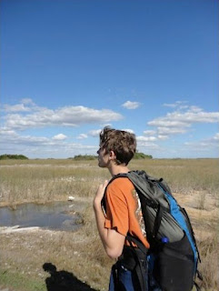
For the last few weeks, I've been taking long walks with a bunch of weight in my new Vapor Trail backpack. My parents are awesomely supportive. Last week my mom and I headed to Shark Valley, a path in the Everglades National Park. She did 8 miles, I did 15. Gators stewed in the murk on either side of the trail (oooh, what a moody sentence). Sea grass prairies remind me of safaris. Halfway along the trail, there's this tower with a broad spiral walkway leading up to the lookout. It was beautiful to see the cloud shadows drifting, the different warm hues of the grass, the expansiveness. And that was only, like, 100 feet in the air! The highest point on the AT, Clingman's Dome in North Carolina, is 6,643 feet high.
Yesterday, my folks and I headed out the front door for Matheson Hammock, a scenic park with a marina, an atoll, and a fancy restaurant (The Red Fish Grill). The trip included coral rock walls, dappled light from overhanging banyons, bougainvillea bushes, and lavish landscaping. At the marina, we saw one of the docked sailboats seem to spontaneously catch on fire (the fire was inside, it was just smoking as far as we could tell, but it was a lot of smoke). On the way back, I explored the Hardy P. Matheson Preserve walkway on Old Cutler Road. It follows Snapper Creek into Biscayne Bay. At first, it seemed hopelessly hot and dreary, but the end was actually enclosed in Australian pine and mangroves. At the end, you could look out in 270 degrees. Prime real estate peeped out of the foliage of the mainland. Miami city rested over sailboats and speed boats in the bay. The hum of their engines reminded me of blowing into an empty bottle. I was pretty psyched to find this shady vantage point. I wish I had the camera, dang.
Well, I'll write as things develop. Stay tuned!
 |
| Turns out I was using more weight than I thought. I should have distributed it better anyway. |
 |
| Check it out, a yellow crowned night heron on the path in Matheson Hammock. Chillin'. |


